What is oblique imagery?
Oblique imagery refers to aerial photography captured at an angle between 40 and 45 degrees. One of the most popular oblique camera systems on the market uses a mechanical rig with five cameras positioned in a cross configuration: one camera pointing directly downward (nadir), and four others tilted at a 45-degree angle.
Unlike traditional orthographic imagery, oblique imagery offers a more realistic depiction of ground features by capturing them from multiple angles. This provides a wealth of additional information, including 3D details of buildings and objects. Oblique images not only show the tops of structures but also their sides, such as building facades. Advanced positioning and modeling techniques enable the creation of detailed 3D city models.
What's the benefit of using oblique imagery?
First, compared to orthophotos, oblique imagery enables users to view ground features from multiple angles, providing a more realistic representation of their actual conditions.
Second, using supporting software, you can directly measure height, length, area, angles, slopes, and more from the resulting images, expanding the application of oblique photography technology.
Third, oblique photography can quickly capture multi-angle and wide-range images of urban areas, overcoming the limitations of traditional images. By tilting the camera, oblique photography can gather more information about ground features, particularly building facades. With the help of massive parallel computing, 3D models based on oblique images can be built swiftly, significantly reducing the cost of urban 3D modeling.
Lastly, the image data obtained through oblique aerial photography is much smaller than that of 3D GIS, and its image data format can be quickly shared over the internet.
How accurate is oblique photography?
Georeferencing involves associating recognizable points with known coordinates in a predetermined reference system (such as UTM or Gauss-Braga) to the image.
In all measurements, there are both geometric and accidental errors. GIS software calculates the types of errors and applies corrections to the image. This involves applying a deformation criterion to the final image that is adapted to the reference system used by the map.
Accidental errors, which depend on the movement of the drone and the morphology of the terrain, are also reduced. They can be corrected by using ground control points.
In the case of oblique photographs, a variable number of Ground Control Points (GCPs) are used on the ground. These points, with known coordinates, are located either homogeneously or concentrated in areas of maximum interest.
The comparison of the values obtained during data collection and the actual position of the points is called residual. The precision of each GCP is measured through a residual value (of x, y).
What are oblique photos used for?
Oblique imagery can be used for a wide variety of purposes, with the main applications including:
- Smart City: The ground feature information obtained through oblique cameras can be used to quickly build 3D models, providing urban planners with consistent, reliable data to visualize projects and evaluate the short and long-term effects of any smart city initiatives.
- Open-pit Mine Management: High-resolution 3D realistic mesh models are ideal starting points for engineering operations, construction, project planning, and communication activities. Use an accurate and fully textured 3D model of your site as a simulation planning sandbox. Model and virtually redesign all your future developments. Use the 3D model to better communicate with your stakeholders to show what you have done, what you are doing, and what you plan to do in the future.
- Planning and Design: Oblique photography can also be used for planning and design, such as the planning and design of bridges. Combining BIM technology and oblique aerial photography, you can build a 3D model of the bridge structure. Meanwhile, also using BIM modeling technology, you can show your real-time dynamic adjustment and 3D dynamic presentation of the bridge design plan.
In addition, oblique photography technology has been widely used in land survey, rural cadastral mapping, river and lake management, real estate rights, engineering measurement, building construction, agriculture and forestry, traffic planning, BIM design, and GIS information system.
Real-world use cases of oblique imagery
Equipped with oblique cameras of different tilt angles, our JOUAV VTOL drones helped numerous customers from various industries obtain more accurate spatial information of ground targets and generate large-scale 3D models quickly.
Water flow study in the Taklimakan desert
The Taklimakan Desert, located in southwestern Xinjiang in northwest China, is the largest desert in China and the second-largest in the world. To study seasonal river generation in the desert, the Xinjiang Institute of Geology used CW-15 with a CA503R five-lens oblique camera to calculate the volume of sediment scoured by rivers.
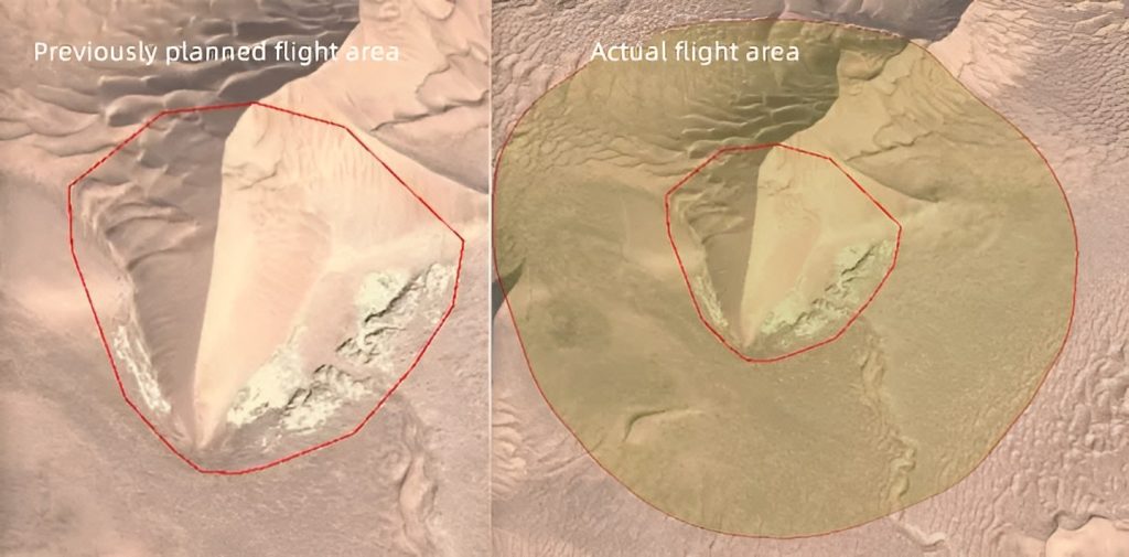
This 3D model covers 2.78km² and was captured in a single flight.
Lily Shee, Superintendent of Technical Services at Xinjiang Institute of Geology, said that a ground survey on this area would take more than 3 days, but with CW-15, they only spent 70 minutes and saved thousands of dollars.
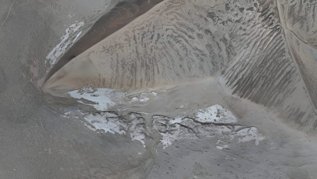
"Using professional 3D design software, we can easily make the 3D model based on oblique images. The 3D model directly shows the river image, which can be used to calculate the river sediment volume more accurately and also can infer the impacts of water flow direction and intensity on the dune," said Lily.
Weinan 3D city modeling project
The Weinan Municipal Government utilized CW-15 VTOL and PH-7E multirotor equipped with CA-503R cameras to capture high-resolution oblique imagery, generating a comprehensive 3D model with accuracies as low as 5cm for a 700 sq. km area. The 3D model aided in promoting the Weinan Snowlight Project by improving construction efficiency, project monitoring, and maintenance management.
"We were blown away by the level of detail and accuracy provided by CW-15 and PH-7E's 3D modeling drones. The ability to capture data from such a high altitude and still have a comprehensive and realistic representation of our site was truly impressive. This technology has completely transformed our approach to urban construction planning and we look forward to utilizing it for future projects," said John Guo, Project Manager from the Weinan Municipal Government.
- Read more about 3D fine modeling in Weinan
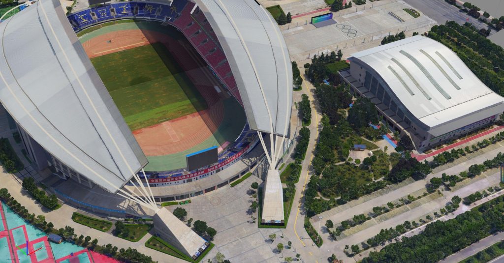
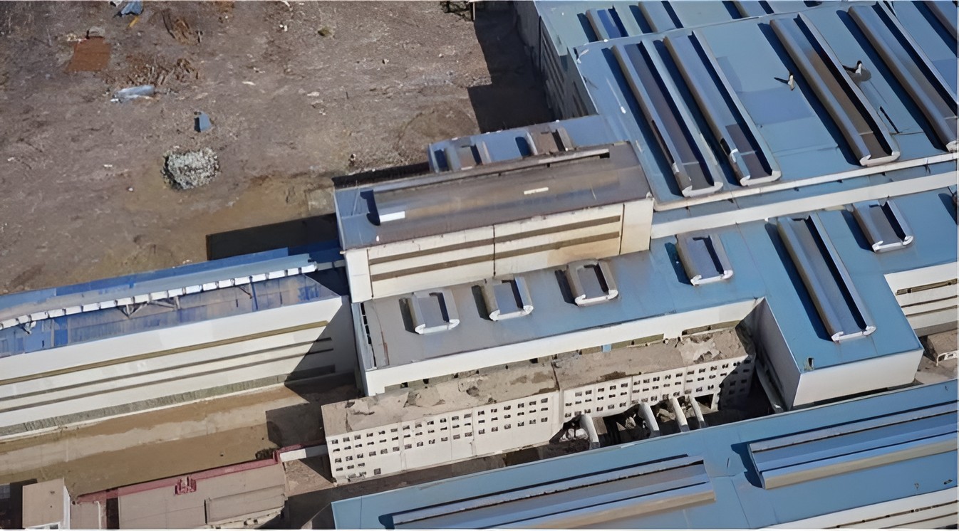
3D model details of the Weinan Gymnasium
Mapping one of the chemical plants in China
Wanhua Chemical Plant, one of the largest chemical plants in China, used CW-25E equipped with a CA503 oblique camera to digitally model the chemical plant. In this way, they can conveniently and intelligently manage the traffic, volume ratio, sewage management, black water, greenery, and garbage in the area.
"It takes one to two years for the manual modeling to complete small and medium-sized city modeling work. But now with the oblique aerial photography, we can be completed the task in only three to five months, which effectively improves the efficiency of 3D model data collection," said Hermann Liu, Manager at Wanhua Chemical Plant.


Conclusion
Oblique imagery recreates the environment from the perspective of a human observer, compared to traditional drone surveying (which is taken straight from above). Since the angle of inclination is greater than in nadir images, the visualization of vertical structures is improved. As a result, the user can immerse themselves in images that allow for quick and instinctive recognition of the objects present in them.
JOUAV drones for 3D mapping can be equipped with five-lens oblique cameras for high-resolution images that meet the survey accuracy required in various industries. At present, JOUAV drones equipped with an oblique photography system are widely used in urban management, land resource management, smart city, emergency response, land security, geological control, power line inspection, and other fields.
Branch Joints,Aux Disperse Branch Pipe Kit,air conditioning fittings, Insulation cover
SUZHOU YOUDE ELECTRIC CO., LTD. , https://www.unitekool.com